
Participatory Grassland and Rangeland Assessment (PRAGA)
Type: Approaches
Creation: 2025-06-29 18:41 Updated: 2025-12-15 12:17
Compilers: Nicholas Euan Sharpe
Reviewers: William Critchley, Rima Mekdaschi Studer
Country/ region/ locations where the Approach has been applied
- Country: Georgia
- Region/ State/ Province: Dmanisi, Gurjaani and Kazbegi Municipalities
- Further specification of location (e.g. municipality, town, etc.), if relevant: Ganakleba, Naniani, Sno
- Map: View Map
Description of the SLM Approach
Short description of the Approach
The Participatory Rangelands and Grasslands Assessment Methodology (PRAGA) is a rapid, cost-effective framework for the integrated assessment of rangeland ecosystems, incorporating diverse data sources and participatory approaches. PRAGA facilitates stakeholder engagement through consultations and workshops, underpinned by community-based mapping of grazing areas, land use dynamics, and trend analyses.
Detailed description of the Approach
The PRAGA methodology is structured around three primary sources of information: (a) stakeholder inputs from Focus Group Discussions, Key Informant Interviews, and participatory mapping exercises; (b) field-based ecological and land-use surveys; and (c) remote sensing data (see: https://www.fao.org/family-farming/detail/en/c/1731318/). These are complemented by national topographic and thematic maps, cadastral records and land tenure documentation. In this project, the assessment outputs were integrated into an interactive, web-based platform, enabling users to visualize, manipulate, and analyse datasets related to land degradation (LD) and productivity dynamics. The tool accommodated a broad spectrum of stakeholder needs, facilitating decision-making across multiple scales and sectors.
The primary objective of PRAGA is to map spatial and temporal trends in ecological condition and LD, incorporating the knowledge, perceptions, and observations of local land users. Integrating such insights with biophysical data ensures that assessments reflect both ecological realities and stakeholder perspectives. After synthesis, this provides a decision-support tool for a broad range of stakeholders. Actions are guided by the LD response hierarchy—Avoid > Reduce > Reverse—with prioritization given to "Avoid" and "Reduce". This framework helps provide an optimal mix of actions, supporting the goal of land degradation neutrality (LDN) while ensuring no net loss of ecosystem function.
For Georgia, the methodology was adapted to the specific context, and the priorities of national and local stakeholders. These adaptations were implemented within the project “Achieving Land Degradation Neutrality Targets of Georgia through Restoration and Sustainable Management of Degraded Pasturelands (MSP),” which aimed to support Georgia in meeting its LDN targets through the restoration and sustainable management of degraded pasture ecosystems.
Implementation followed a specifically developed stepwise manual. This focused on capacity building for the Ministry of Environmental Protection and Agriculture of Georgia (MEPA), enabling them to monitor and evaluate the effectiveness of decision-making processes within the project-developed Municipal Pasture Planning (MPP) approach.
Stakeholder engagement included a broad spectrum of actors: pasture users, representatives from national, municipal, and town-level administrations, technical staff, NGOs, conservation organizations, and neighbouring communities. All participants played an active role by contributing qualitative insights and field-based observations related to: a) the current condition of pastures, b) observed ecological changes and pasture evolution, c) the extent and severity of land degradation, including the mapping of both high-quality and degraded areas, d) perceived impacts of management practices on landscape health, e) recommendations for actions needed to conserve or improve rangeland conditions and f) identification of context-specific indicators to capture ecological and productivity trends.
Pastureland users have long expressed concern over the decline in quality and extent of communally managed grasslands. Their familiarity with the landscape enables them to accurately identify and map areas affected by degradation. This project empowered local communities and national stakeholders to define and prioritize context-specific indicators of land health and degradation. The resulting information was provided to the Municipal Pasture Working Groups, serving as a critical platform for articulating priorities and guiding public investment decisions aimed at combating land degradation. Given the history and pastoral resources currently found in Georgia’s rural areas, the project piloted the use of a Controlled Grazing technology as a means to more efficiently utilise grazing and animal impact as a tool to conserve and restore pasturelands and biodiversity at scale. PRAGA is well suited to serve as a feedback loop to determine trends and achievement towards these goals.
Photos of the Approach
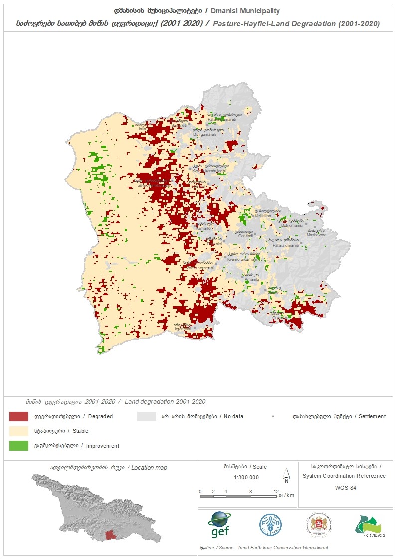
- 📍 Dmanisi, Georgia
- 📷 Regional Environmental Centre for the Caucasus (REC Caucasus)
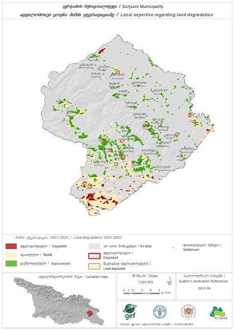
- 📍 Gurjaani, Georgia
- 📷 Regional Environmental Centre for the Caucasus (REC Caucasus)
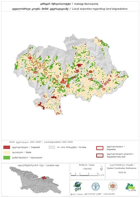
- 📍 Kazbegi, Georgia
- 📷 Regional Environmental Centre for the Caucasus (REC Caucasus)
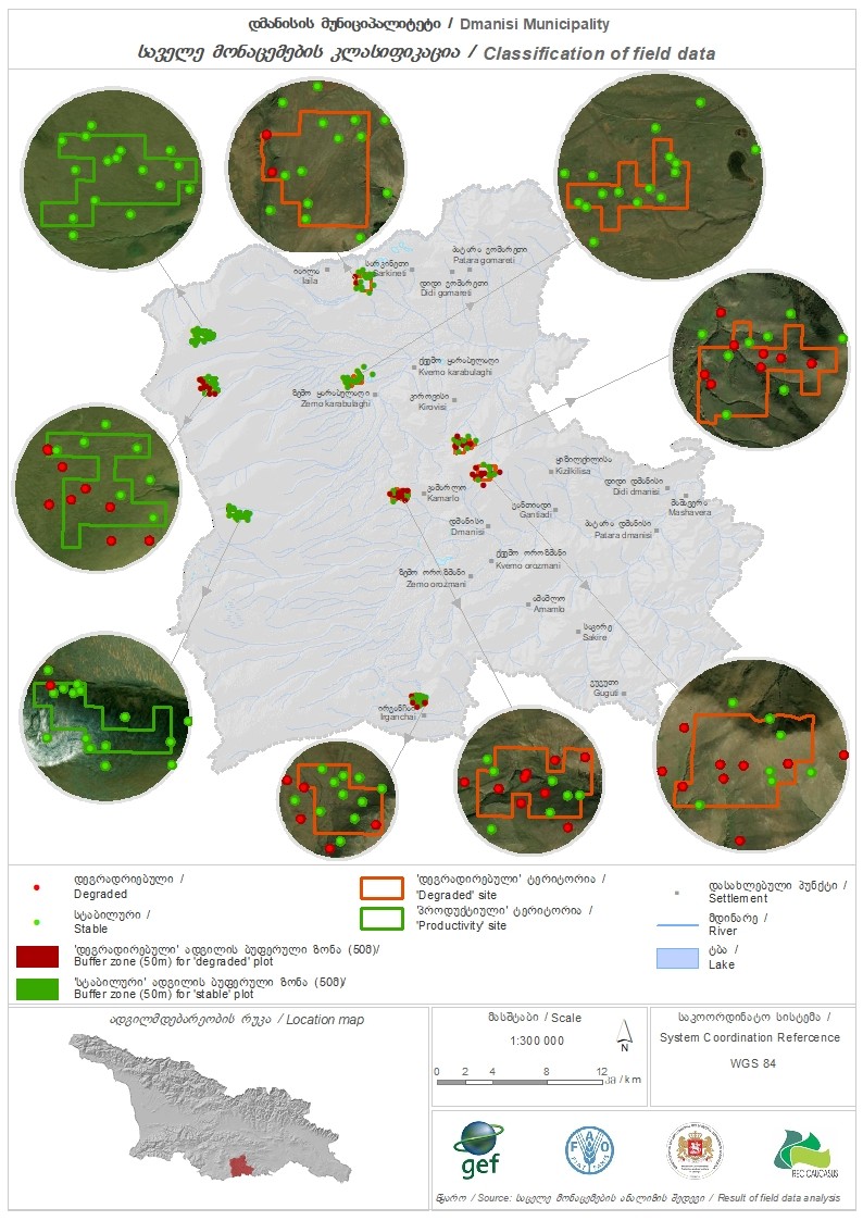
- 📍 Dmanisi, Georgia
- 📷 Regional Environmental Centre for the Caucasus (REC Caucasus)

- 📷 Regional Environmental Centre for the Caucasus (REC Caucasus)