
Monitoring the condition of pastures (CACILM)
Type: Technologies
Creation: 2013-02-13 18:18 Updated: 2019-05-09 15:15
Compilers: Azamat Isakov
Reviewers: Fabian Ottiger, David Streiff, Alexandra Gavilano
Country/ region/ locations where the Technology has been applied and which are covered by this assessment
- Country: Kyrgyzstan
- Region/ State/ Province: Kyrgyz Republic
- Further specification of location (e.g. municipality, town, etc.), if relevant: Naryn province
- Map: View Map
Description of the SLM Technology
Short description of the Technology
Monitoring the state condition of pastures.
Detailed description of the Technology
The monitoring of pastures is one of the powers of the Pasture Committee; It serves as a basis for developing a pasture use plan. This is a new task for the Pasture Committees, which requires specialized knowledge. Therefore, a simple method for evaluating pasture condition was developed:
1. Select an area on which the yield will be determined (place the prepared frame with an area of 1m2), specify the position coordinates (control points) of the selected area on the map using GPS.
2. Indicate the name of the area and information on the condition of the pasture area (erosion, salinization, etc.).
3. Photograph the area, which allows for a visual comparison of the vegetation development during the year.
4. Assess the vegetation cover inside the frame and measure the height of the vegetation with a ruler. Identify the types of plants in the square and divide them into palatable and non-palatable. Arrange the plants in the pouches, write notes about the place of withdrawal of the plant and indicate the date of withdrawal (use a pencil).
5. Determine the yield of the studied forage lands with the cut-sample method: the grass is mowed on 1 m2 (with a 5-fold repeatability). The cutting height should be 7-8 cm for hay, 4-6 cm for short grass pastures, and 6-7 cm for tall grass pastures. Move the frame consistently 5m diagonally from the corner of each control point.
6. Weigh the sample in raw condition and after drying and divide into palatable and non-palatable.
7. Calculate the yield for each type of pasture.
(in the frame of CACILM)
Purpose of the Technology: This approach enables a timely detection of changes in the condition and productivity of pastures under the influence of both anthropogenic and climatic factors. It also facilitates an assessment of such changes, in order to prevent and eliminate negative processes of pasture degradation.
Establishment / maintenance activities and inputs: Specialists from CAMP Alatoo together with Kyrgyz Designing Institute on Land Management “Kyrgyzgiprozem”.developed a farmer's method to assess the productivity of pastures and conducted a training seminar on "Monitoring of pastures". Currently, each ayil okrug (A/O, aiyl okrug is an administrative and territorial unit consists of a group of villages, which has a local self-government) of the pilot area has a person responsible for the monitoring of pastures. The obtained data are updated, compared and linked to weather conditions (temperature, precipitation).
Natural / human environment: Naryn province is located at an altitude of 1800-4500 above sea level. Annual precipitation - 200-500 mm in summer (April-October) and 100-200 mm in winter (November-March). The population is traditionally involved in animal husbandry. The pasture vegetation is rich in diversity. Different altitudinal belts, the variety of climatic conditions and the exclusivity of the regional geographic areas determine the diversity of pasture vegetation and hay harvest. They differ from each other according to content and grass composition, as well as yield and forage quality.
Photos of the Technology
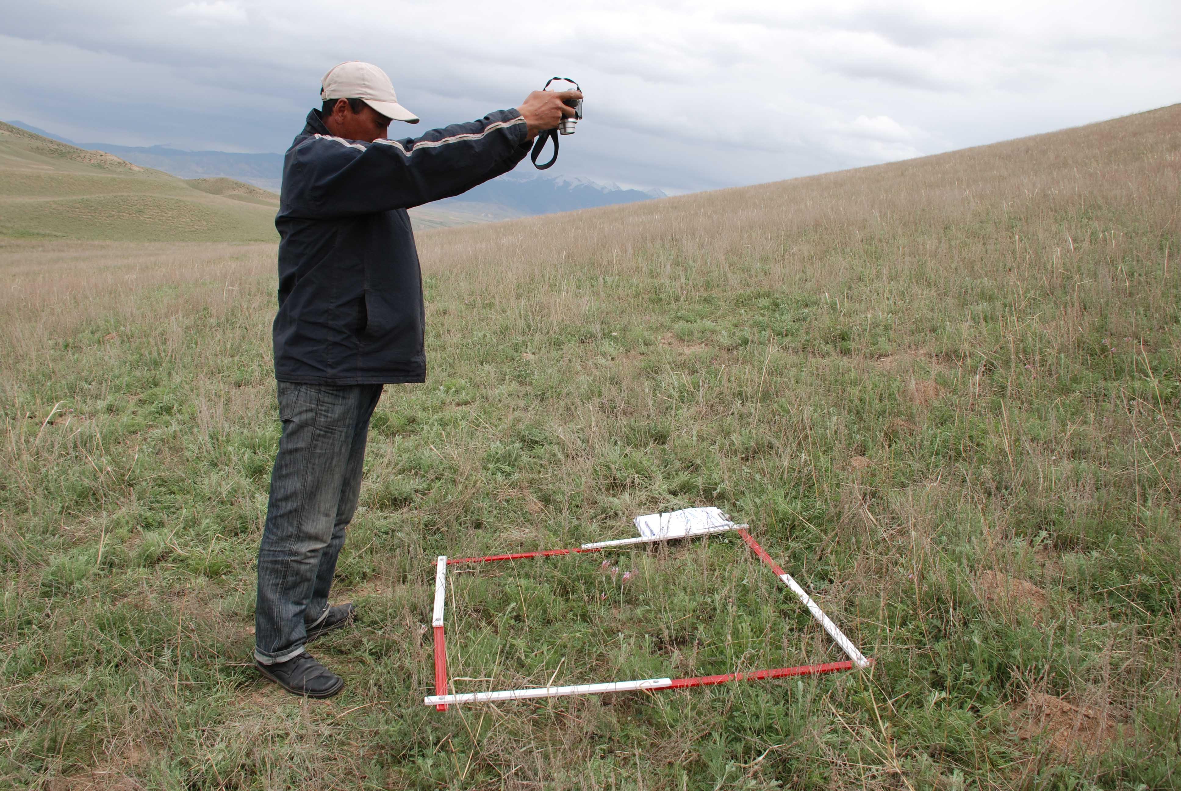
- 📍 Jergatal village, Naryn district, Naryn province
- 🗓 2009-11-08
- 📷 Archives of САМР Alatoo (3, Uphimskiy pereulok, Bishkek)
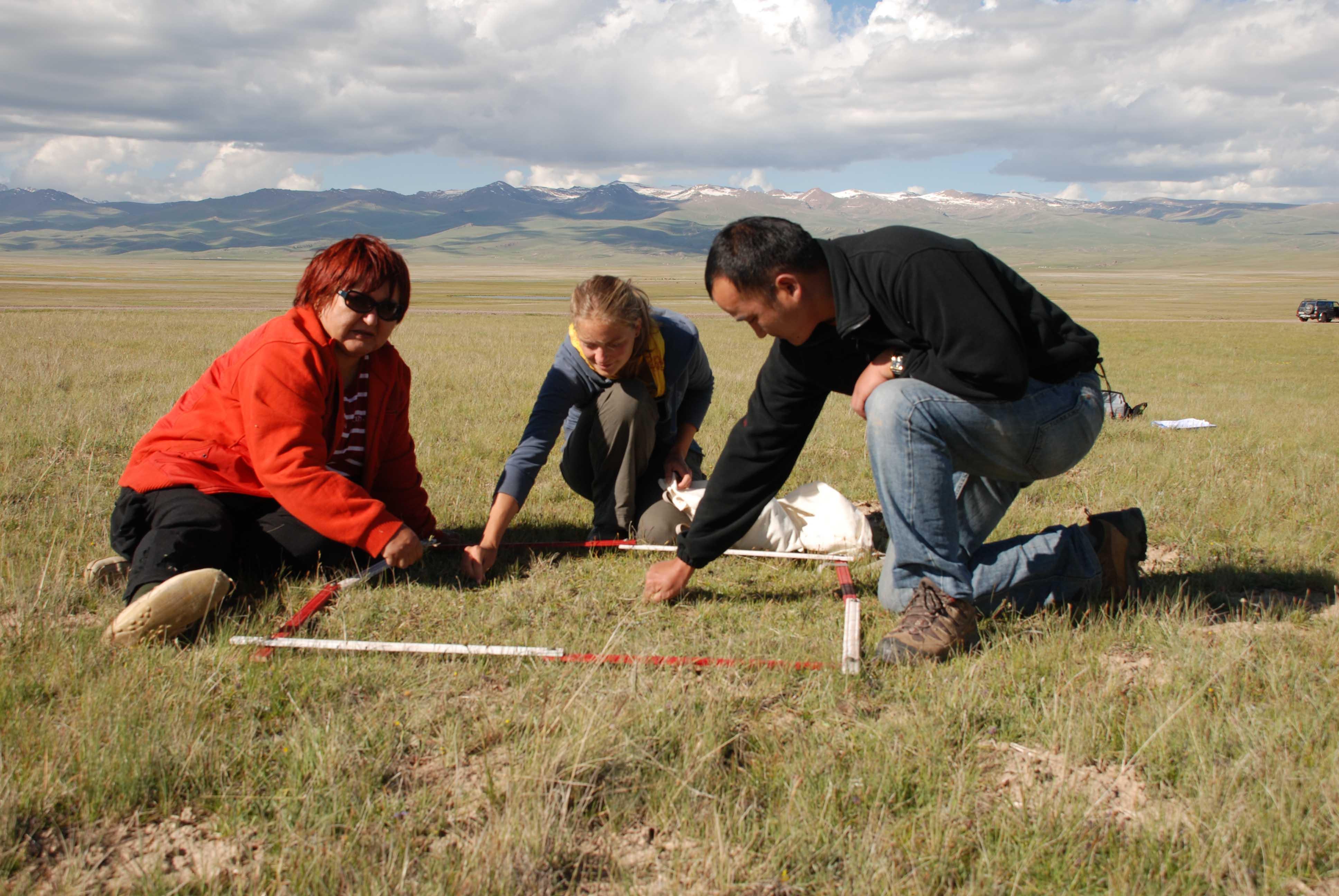
- 📍 Jergatal village, Naryn district, Naryn province
- 🗓 2011-11-08
- 📷 Archives of САМР Alatoo (3, Uphimskiy pereulok, Bishkek)