
Farm pond
Type: Technologies
Creation: 2011-06-03 13:39 Updated: 2019-09-04 22:32
Compilers: Channabasappa Metri
Reviewers: Fabian Ottiger, Alexandra Gavilano
Country/ region/ locations where the Technology has been applied and which are covered by this assessment
- Country: India
- Region/ State/ Province: Karnataka
- Further specification of location (e.g. municipality, town, etc.), if relevant: Bijapur district, Hadalsang village
- Map: View Map
Description of the SLM Technology
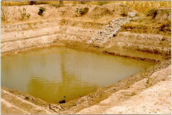
Short description of the Technology
A sunken structure (12 x 12 x 3 m, more suiable), constructed by escavation in arable land with a view of temporary runoff storage tapped for protective irrigation, and to increase percolation for recharge of ground water (to convert surface to subsurface flow)
Detailed description of the Technology
A farm pond comprises of excavated portions of 12 x 12 x 3 m with the steps at 0.6m depth each. The excavated earth is deposited all around the structure as a bund, with a burm space of 1m. An inlet cum outlet provided in the course of flow of rain water to collect and dispose the excess runoff.
Purpose of the Technology: (1). For storage of exess runoff. (2) to increase percolation for ground water recharge, (3). To use for protective irrigation during dry period, (4). To stop further deepening of watercourse in arable lands
Establishment / maintenance activities and inputs: Selection of beneficiary is by the community and site selection, Design/ layout and excavation by the project staff with participation of the beneficiary. Desilting of the structure is by the beneficiary
Natural / human environment: surrounding lands are more slopy and with exposed rocks, most of the surrounding area is left for grazing
Photos of the Technology
- 📍 kallahalla nala watershed, Indi taluk of Bijapur district (Karnataka state)
- 🗓 2000-04-04
- 📷 C.G. Metri, JPO, KWDP Danida